


Canada has a giant zombie in it
I discovered this year that something I've seen a zillion times, the standard map of Canada, features a giant, brain-eating zombie. I'm naming the zombie "Hudson" because that's the Bay that makes up most of him. He's a plump undead with stubby legs, a big blank eye (Price Charles Island,) and a slack jaw, and it looks like Newfoundland is in trouble.
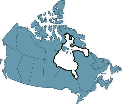
The way the human mind likes to find figures and faces in natural patterns is called pareidolia but what surprises me is that in spite of seeing this map so often, I never saw Hudson until recently, and based on web searches, neither has anybody else.
But now I find it difficult to look at the regular map, without highlights, and not see the zombie.

He is so big he may be a cosmological zombie. They eat "branes, branes."


Comments
Phillip Helbig
Mon, 2011-07-04 23:57
Permalink
land area
Thanks to the zombie, Canada is the second-largest country in the world by area.
Without the zombie (i.e. counting only land area), the US and China surpass it,
bringing it down to #4. (The largest country in the world, either way, by far,
is Russia.)
brad
Sat, 2023-10-28 16:58
Permalink
Larger land area
No, that's not correct. Hudson is not generally included in the land area of Canada. However, all the many freshwater lakes are generally included in the area of countries, but not bays onto the oceans. Canada is smaller if you remove the freshwater lakes, but generally nobody removes that.
Ross
Mon, 2011-10-03 18:39
Permalink
I used to have a satellite
I used to have a satellite photo of the SF Bay Area hanging in my living room. For about 15 years, I never saw any strange shapes. The one night it just hit me, I saw a bear tossing a peanut into his open mouth. The east bay hills are the head, the shoreline around Crockett form the rounded top of the head, the concave shoreline of Emeryville-Berkeley-Richmond are the open mouth, Pt San Pablo is the tip of the nose, the peninsula is the "arm" and San Francisco is the "paw". Treasure Island is the peanut. Now it is impossible to look at any map or photo of the Bay Area without seeing that bear!
Anonymous
Tue, 2012-01-17 13:25
Permalink
This honestly made me laugh
This honestly made me laugh out loud. I almost spit out my coke.
Victoria Detail
Sat, 2023-10-28 15:39
Permalink
It does look like a zombie
Haha cheers to you for noticing it. Gonna show this to my friends this Halloween!
Kind regards from Victoria, BC
https://www.autodetailingvictoria.com/
Add new comment